1747 Bowen Map of Carolina, Georgia and Florida
Brandywine General Store
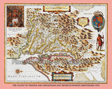
An art Print of 1747 Bowen Map of Carolina, Georgia and Florida for sale by Brandywine General Store. Our cartography artwork was portrayed as a New and Accurate Map of the Provinces of North and South Carolina by Emanuel Bowen. Bowen's remarkable 1747 map of the southeastern part of North America, covering the areas from the mouth of the Chesapeake Bay to St. Augustine, Florida and from Louisiana to the Atlantic. This was originally produced for the 2nd edition of Bowen's important Complete System of Geography. The coast lands are well settled and exhibit considerable European development, however, only a short distance inland European settlements quickly give way to unexplored lands and the territories claimed by powerful American Indian Nations. Bowen makes a large notation explaining the alliance of the 1745 treaty with the Cherokee and Catawaa tribes with the English in what is today Kentucky and Tennessee. This created a critical buffer zone between the French and British empires in America. At the same time this treaty opened up Cherokee Lands to British Merchants and traders. Several Spanish Missions are shown in Florida namely: St. Francisco, St. Peter, St. Matthew, St. John, St. Paul and St. Mark. This map also shows the southern parts of the colony of Virginia, all of the lands west of Virginia and Carolina is labeled as Cherokee, while the southwestern part is shown as Louisiana which extends all the way over to the Carolinas. Florida is labeled as being full of swamps and the before named Spanish Missions. The coast is fully charted with names of all the towns along the ocean. Picture #10 an archival premium quality cartography artwork of early America.


